Make a Spatial Query
-
Documents that contain spatial data can be queried by spatial queries that employ geographical criteria.
You have two options:-
Dynamic spatial query
Either make a dynamic spatial query on a collection ( described in this article ).
An auto-index will be created by the server. -
Spatial index query
Or, index your documents' spatial data in a static-index (see indexing spatial data),
and then make a spatial query on this index (see query a spatial index).
-
-
To perform a spatial search,
use theSpatialmethod which provides a wide range of spatial functionalities. -
When making a dynamic spatial query from the Studio,
results are also displayed on the global map. See spatial queries map view. -
In this page:
Search by radius
Use the WithinRadius method to search for all documents containing spatial data that is located
within the specified distance from the given center point.
- Query
- Query_async
- DocumentQuery
- RQL
// This query will return all matching employee entities
// that are located within 20 kilometers radius
// from point (47.623473 latitude, -122.3060097 longitude).

// Define a dynamic query on Employees collection
List<Employee> employeesWithinRadius = session
  .Query<Employee>()
   // Call 'Spatial' method
  .Spatial(
      // Call 'Point'
      // Pass the path to the document fields containing the spatial data
      pointField => pointField.Point(
          x => x.Address.Location.Latitude,
          x => x.Address.Location.Longitude),
      // Set the geographical area in which to search for matching documents
      // Call 'WithinRadius', pass the radius and the center points coordinates
      criteria => criteria.WithinRadius(20, 47.623473, -122.3060097))
  .ToList();
// This query will return all matching employee entities
// that are located within 20 kilometers radius
// from point (47.623473 latitude, -122.3060097 longitude).

// Define a dynamic query on Employees collection
List<Employee> employeesWithinRadius = await asyncSession
  .Query<Employee>()
   // Call 'Spatial' method
  .Spatial(
      // Call 'Point'
      // Pass the path to the document fields containing the spatial data
      pointField => pointField.Point(
          x => x.Address.Location.Latitude,
          x => x.Address.Location.Longitude),
      // Set the geographical area in which to search for matching documents
      // Call 'WithinRadius', pass the radius and the center points coordinates
      criteria => criteria.WithinRadius(20, 47.623473, -122.3060097))
  .ToListAsync();
// This query will return all matching employee entities
// that are located within 20 kilometers radius
// from point (47.623473 latitude, -122.3060097 longitude).

// Define a dynamic query on Employees collection
List<Employee> employeesWithinRadius = session.Advanced
  .DocumentQuery<Employee>()
  // Call 'Spatial' method
  .Spatial(
      // Call 'Point'
      // Pass the path to the document fields containing the spatial data
      pointField => pointField.Point(
          x => x.Address.Location.Latitude,
          x => x.Address.Location.Longitude),
      // Set the geographical area in which to search for matching documents
      // Call 'WithinRadius', pass the radius and the center points coordinates
      criteria => criteria.WithinRadius(20, 47.623473, -122.3060097))
  .ToList();
// This query will return all matching employee entities
// that are located within 20 kilometers radius
// from point (47.623473 latitude, -122.3060097 longitude).

from Employees
where spatial.within(
  spatial.point(Address.Location.Latitude, Address.Location.Longitude),
  spatial.circle(20, 47.623473, -122.3060097)
)
Search by shape
-
Use the
RelatesToShapemethod to search for all documents containing spatial data that is located
in the specified relation to the given shape. -
The shape is specified as either a circle or a polygon in a WKT format.
-
The relation to the shape can be one of:
Within,Contains,Disjoint,Intersects.
- Query
- Query_async
- DocumentQuery
- RQL
// This query will return all matching employee entities
// that are located within 20 kilometers radius
// from point (47.623473 latitude, -122.3060097 longitude).

// Define a dynamic query on Employees collection
List<Employee> employeesWithinShape = session
  .Query<Employee>()
   // Call 'Spatial' method
  .Spatial(
      // Call 'Point'
      // Pass the path to the document fields containing the spatial data
      factory => factory.Point(
          x => x.Address.Location.Latitude,
          x => x.Address.Location.Longitude),
      // Set the geographical search criteria, call 'RelatesToShape'
      criteria => criteria.RelatesToShape(
          // Specify the WKT string. Note: longitude is written FIRST
          shapeWkt: "CIRCLE(-122.3060097 47.623473 d=20)",
          // Specify the relation between the WKT shape and the documents spatial data
          relation: SpatialRelation.Within,
          // Optional: customize radius units (default is Kilometers)
          units: SpatialUnits.Miles))
  .ToList();
// This query will return all matching employee entities
// that are located within 20 kilometers radius
// from point (47.623473 latitude, -122.3060097 longitude).

// Define a dynamic query on Employees collection
List<Employee> employeesWithinShape = await asyncSession
  .Query<Employee>()
   // Call 'Spatial' method
  .Spatial(
      // Call 'Point'
      // Pass the path to the document fields containing the spatial data
      factory => factory.Point(
          x => x.Address.Location.Latitude,
          x => x.Address.Location.Longitude),
      // Set the geographical search criteria, call 'RelatesToShape'
      criteria => criteria.RelatesToShape(
          // Specify the WKT string. Note: longitude is written FIRST
          shapeWkt: "CIRCLE(-122.3060097 47.623473 d=20)",
          // Specify the relation between the WKT shape and the documents spatial data
          relation: SpatialRelation.Within,
          // Optional: customize radius units (default is Kilometers)
          units: SpatialUnits.Miles))
  .ToListAsync();
// This query will return all matching employee entities
// that are located within 20 kilometers radius
// from point (47.623473 latitude, -122.3060097 longitude).

// Define a dynamic query on Employees collection
List<Employee> employeesWithinShape = session.Advanced
  .DocumentQuery<Employee>()
   // Call 'Spatial' method
  .Spatial(
      // Call 'Point'
      // Pass the path to the document fields containing the spatial data
      factory => factory.Point(
          x => x.Address.Location.Latitude,
          x => x.Address.Location.Longitude),
      // Set the geographical search criteria, call 'RelatesToShape'
      criteria => criteria.RelatesToShape(
          // Specify the WKT string. Note: longitude is written FIRST
          shapeWkt: "CIRCLE(-122.3060097 47.623473 d=20)",
          // Specify the relation between the WKT shape and the documents spatial data
          relation: SpatialRelation.Within,
          // Optional: customize radius units (default is Kilometers)
          units: SpatialUnits.Miles))
  .ToList();
// This query will return all matching employee entities
// that are located within 20 kilometers radius
// from point (47.623473 latitude, -122.3060097 longitude).

from Employees
where spatial.within(
  spatial.point(Address.Location.Latitude, Address.Location.Longitude),
  spatial.wkt("CIRCLE(-122.3060097 47.623473 d=20)", "miles")
)
- Query
- Query_async
- DocumentQuery
- RQL
// This query will return all matching company entities
// that are located within the specified polygon.
// Define a dynamic query on Companies collection
List<Company> companiesWithinShape = session
.Query<Company>()
// Call 'Spatial' method
.Spatial(
// Call 'Point'
// Pass the path to the document fields containing the spatial data
factory => factory.Point(
x => x.Address.Location.Latitude,
x => x.Address.Location.Longitude),
// Set the geographical search criteria, call 'RelatesToShape'
criteria => criteria.RelatesToShape(
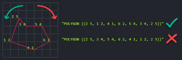
// Specify the WKT string
shapeWkt: @"POLYGON ((
-118.6527948 32.7114894,
-95.8040242 37.5929338,
-102.8344151 53.3349629,
-127.5286633 48.3485664,
-129.4620208 38.0786067,
-118.7406746 32.7853769,
-118.6527948 32.7114894
))",
// Specify the relation between the WKT shape and the documents spatial data
relation: SpatialRelation.Within))
.ToList();
// This query will return all matching company entities
// that are located within the specified polygon.

// Define a dynamic query on Companies collection
List<Company> companiesWithinShape = await asyncSession
  .Query<Company>()
   // Call 'Spatial' method
  .Spatial(
      // Call 'Point'
      // Pass the path to the document fields containing the spatial data
      factory => factory.Point(
          x => x.Address.Location.Latitude,
          x => x.Address.Location.Longitude),
      // Set the geographical search criteria, call 'RelatesToShape'
      criteria => criteria.RelatesToShape(
          // Specify the WKT string
          shapeWkt: @"POLYGON ((
                         -118.6527948 32.7114894,
                         -95.8040242 37.5929338,
                         -102.8344151 53.3349629,
                         -127.5286633 48.3485664,
                         -129.4620208 38.0786067,
                         -118.7406746 32.7853769,
                         -118.6527948 32.7114894
                    ))",
          // Specify the relation between the WKT shape and the documents spatial data
          relation: SpatialRelation.Within))
  .ToListAsync();
// This query will return all matching company entities
// that are located within the specified polygon.

// Define a dynamic query on Companies collection
List<Company> companiesWithinShape = session.Advanced
  .DocumentQuery<Company>()
  // Call 'Spatial' method
  .Spatial(
      // Call 'Point'
      // Pass the path to the document fields containing the spatial data
      factory => factory.Point(
          x => x.Address.Location.Latitude,
          x => x.Address.Location.Longitude),
      // Set the geographical search criteria, call 'RelatesToShape'
      criteria => criteria.RelatesToShape(
          // Specify the WKT string
          shapeWkt: @"POLYGON ((
                         -118.6527948 32.7114894,
                         -95.8040242 37.5929338,
                         -102.8344151 53.3349629,
                         -127.5286633 48.3485664,
                         -129.4620208 38.0786067,
                         -118.7406746 32.7853769,
                         -118.6527948 32.7114894
                    ))",
          // Specify the relation between the WKT shape and the documents spatial data
          relation: SpatialRelation.Within))
  .ToList();
// This query will return all matching company entities
// that are located within the specified polygon.

from companies
where spatial.within(
  spatial.point(Address.Location.Latitude, Address.Location.Longitude),
  spatial.wkt("POLYGON ((
      -118.6527948 32.7114894,
      -95.8040242 37.5929338,
      -102.8344151 53.3349629,
      -127.5286633 48.3485664,
      -129.4620208 38.0786067,
      -118.7406746 32.7853769,
      -118.6527948 32.7114894))")
)
Spatial sorting
-
Use
OrderByDistanceorOrderByDistanceDescendingto sort the results by distance from a given point. -
By default, distance in RavenDB measured in kilometers.
The distance can be rounded to a specific range.
- Query
- Query_async
- DocumentQuery
- RQL
// Return all matching employee entities located within 20 kilometers radius
// from point (47.623473 latitude, -122.3060097 longitude).

// Sort the results by their distance from a specified point,
// the closest results will be listed first.

List<Employee> employeesSortedByDistance = session
  .Query<Employee>()
   // Provide the query criteria:
  .Spatial(
      pointField => pointField.Point(
          x => x.Address.Location.Latitude,
          x => x.Address.Location.Longitude
      ),
      criteria => criteria.WithinRadius(20, 47.623473, -122.3060097))
   // Call 'OrderByDistance'
  .OrderByDistance(
      factory => factory.Point(
          // Pass the path to the document fields containing the spatial data
          x => x.Address.Location.Latitude,
          x => x.Address.Location.Longitude
      ),
      // Sort the results by their distance from this point:
      47.623473, -122.3060097)
  .ToList();
// Return all matching employee entities located within 20 kilometers radius
// from point (47.623473 latitude, -122.3060097 longitude).

// Sort the results by their distance from a specified point,
// the closest results will be listed first.

List<Employee> employeesSortedByDistance = await asyncSession
  .Query<Employee>()
   // Provide the query criteria:
  .Spatial(
      pointField => pointField.Point(
          x => x.Address.Location.Latitude,
          x => x.Address.Location.Longitude
      ),
      criteria => criteria.WithinRadius(20, 47.623473, -122.3060097))
   // Call 'OrderByDistance'
  .OrderByDistance(
      factory => factory.Point(
          // Pass the path to the document fields containing the spatial data
          x => x.Address.Location.Latitude,
          x => x.Address.Location.Longitude
      ),
      // Sort the results by their distance from this point:
      47.623473, -122.3060097)
  .ToListAsync();
// Return all matching employee entities located within 20 kilometers radius
// from point (47.623473 latitude, -122.3060097 longitude).

// Sort the results by their distance from a specified point,
// the closest results will be listed first.

List<Employee> employeesSortedByDistance = session.Advanced
  .DocumentQuery<Employee>()
   // Provide the query criteria:
  .Spatial(
      pointField => pointField.Point(
          x => x.Address.Location.Latitude,
          x => x.Address.Location.Longitude
      ),
      criteria => criteria.WithinRadius(20, 47.623473, -122.3060097))
   // Call 'OrderByDistance'
  .OrderByDistance(
      factory => factory.Point(
          // Pass the path to the document fields containing the spatial data
          x => x.Address.Location.Latitude,
          x => x.Address.Location.Longitude
      ),
      // Sort the results by their distance from this point:
      47.623473, -122.3060097)
  .ToList();
// Return all matching employee entities located within 20 kilometers radius
// from point (47.623473 latitude, -122.3060097 longitude).

// Sort the results by their distance from a specified point,
// the closest results will be listed first.

from Employees
where spatial.within(
  spatial.point(Address.Location.Latitude, Address.Location.Longitude),
  spatial.circle(20, 47.623473, -122.3060097)
)
order by spatial.distance(
  spatial.point(Address.Location.Latitude, Address.Location.Longitude),
  spatial.point(47.623473, -122.3060097)
)
- Query
- Query_async
- DocumentQuery
- RQL
// Return all employee entities sorted by their distance from a specified point.
// The farthest results will be listed first.

List<Employee> employeesSortedByDistanceDesc = session
  .Query<Employee>()
   // Call 'OrderByDistanceDescending'
  .OrderByDistanceDescending(
      factory => factory.Point(
          // Pass the path to the document fields containing the spatial data
          x => x.Address.Location.Latitude,
          x => x.Address.Location.Longitude
      ),
      // Sort the results by their distance (descending) from this point:
      47.623473, -122.3060097)
  .ToList();
// Return all employee entities sorted by their distance from a specified point.
// The farthest results will be listed first.

List<Employee> employeesSortedByDistanceDesc = await asyncSession
  .Query<Employee>()
   // Call 'OrderByDistanceDescending'
  .OrderByDistanceDescending(
      factory => factory.Point(
          // Pass the path to the document fields containing the spatial data
          x => x.Address.Location.Latitude,
          x => x.Address.Location.Longitude
      ),
      // Sort the results by their distance (descending) from this point:
      47.623473, -122.3060097)
  .ToListAsync();
// Return all employee entities sorted by their distance from a specified point.
// The farthest results will be listed first.

List<Employee> employeesSortedByDistanceDesc = session.Advanced
  .DocumentQuery<Employee>()
   // Call 'OrderByDistanceDescending'
  .OrderByDistanceDescending(
      factory => factory.Point(
          // Pass the path to the document fields containing the spatial data
          x => x.Address.Location.Latitude,
          x => x.Address.Location.Longitude
      ),
      // Sort the results by their distance (descending) from this point:
      47.623473, -122.3060097)
  .ToList();
// Return all employee entities sorted by their distance from a specified point.
// The farthest results will be listed first.

from Employees
order by spatial.distance(
  spatial.point(Address.Location.Latitude, Address.Location.Longitude),
  spatial.point(47.623473, -122.3060097)
) desc
Sort results by rounded distance:
- Query
- Query_async
- DocumentQuery
- RQL
// Return all employee entities.
// Results are sorted by their distance to a specified point rounded to the nearest 100 km interval.
// A secondary sort can be applied within the 100 km range, e.g. by field LastName.

List<Employee> employeesSortedByRoundedDistance = session
  .Query<Employee>()
   // Call 'OrderByDistance'
  .OrderByDistance(
      factory => factory.Point(
              // Pass the path to the document fields containing the spatial data
              x => x.Address.Location.Latitude,
              x => x.Address.Location.Longitude)
           // Round up distance to 100 km
          .RoundTo(100),
      // Sort the results by their distance from this point:
      47.623473, -122.3060097)
   // A secondary sort can be applied
  .ThenBy(x => x.LastName)
  .ToList();
// Return all employee entities.
// Results are sorted by their distance to a specified point rounded to the nearest 100 km interval.
// A secondary sort can be applied within the 100 km range, e.g. by field LastName.

List<Employee> employeesSortedByRoundedDistance = await asyncSession
  .Query<Employee>()
   // Call 'OrderByDistance'
  .OrderByDistance(
      factory => factory.Point(
              // Pass the path to the document fields containing the spatial data
              x => x.Address.Location.Latitude,
              x => x.Address.Location.Longitude)
           // Round up distance to 100 km
          .RoundTo(100),
      // Sort the results by their distance from this point:
      47.623473, -122.3060097)
   // A secondary sort can be applied
  .ThenBy(x => x.LastName)
  .ToListAsync();
// Return all employee entities.
// Results are sorted by their distance to a specified point rounded to the nearest 100 km interval.
// A secondary sort can be applied within the 100 km range, e.g. by field LastName.

List<Employee> employeesSortedByRoundedDistance = session.Advanced
  .DocumentQuery<Employee>()
   // Call 'OrderByDistance'
  .OrderByDistance(
      factory => factory.Point(
              // Pass the path to the document fields containing the spatial data
              x => x.Address.Location.Latitude,
              x => x.Address.Location.Longitude)
           // Round up distance to 100 km
          .RoundTo(100),
      // Sort the results by their distance from this point:
      47.623473, -122.3060097)
   // A secondary sort can be applied
  .OrderBy(x => x.LastName)
  .ToList();
// Return all employee entities.
// Results are sorted by their distance to a specified point rounded to the nearest 100 km interval.
// A secondary sort can be applied within the 100 km range, e.g. by field LastName.

from Employees
order by spatial.distance(
  spatial.point(Address.Location.Latitude, Address.Location.Longitude),
  spatial.point(47.623473, -122.3060097),
  100
), LastName
- The distance is available in the
@spatialmetadata property within each result.
// Get the distance of the results:
// ================================

// Call 'GetMetadataFor', pass an entity from the resulting employees list
var metadata = session.Advanced.GetMetadataFor(employeesSortedByDistance[0]);

// The distance is available in the '@spatial' metadata property
var spatialResults = (IDictionary<string, object>)metadata[Constants.Documents.Metadata.SpatialResult];

var distance = spatialResults["Distance"];   // The distance of the entity from the queried location
var latitude = spatialResults["Latitude"];   // The entity's longitude value
var longitude = spatialResults["Longitude"]; // The entity's longitude value
Spatial API
Spatial
IRavenQueryable<T> Spatial<T>(
  Expression<Func<T, object>> path,
  Func<SpatialCriteriaFactory, SpatialCriteria> clause);

IRavenQueryable<T> Spatial<T>(
  string fieldName,
  Func<SpatialCriteriaFactory, SpatialCriteria> clause);

IRavenQueryable<T> Spatial<T>(
  Func<DynamicSpatialFieldFactory<T>, DynamicSpatialField> field,
  Func<SpatialCriteriaFactory, SpatialCriteria> clause);

IRavenQueryable<T> Spatial<T>(
  DynamicSpatialField field,
  Func<SpatialCriteriaFactory, SpatialCriteria> clause);
| Parameters | Type | Description |
|---|---|---|
| path | Expression<Func<T, object>> | Path to spatial field in an index (when querying an index) |
| fieldName | string | Path to spatial field in an index (when querying an index) |
| field | Func<DynamicSpatialFieldFactory<T>, DynamicSpatialField>or DynamicSpatialField | Factory or field that points to a document field (when making a dynamic query). Either PointField or WktField. |
| clause | Func<SpatialCriteriaFactory, SpatialCriteria> | Spatial criteria that will be executed on a given spatial field |
DynamicSpatialFieldFactory
PointField Point(
  Expression<Func<T, object>> latitudePath,
  Expression<Func<T, object>> longitudePath);

WktField Wkt(Expression<Func<T, object>> wktPath);
| Parameters | Type | Description |
|---|---|---|
| latitudePath / longitudePath / wktPath | Expression<Func<T, object>> | Path to the field in a document containing either longitude, latitude or WKT |
SpatialCriteriaFactory
SpatialCriteria RelatesToShape(
  string shapeWkt,
  SpatialRelation relation,
  double distErrorPercent = Constants.Documents.Indexing.Spatial.DefaultDistanceErrorPct);

SpatialCriteria RelatesToShape(
  string shapeWkt,
  SpatialRelation relation,
  SpatialUnits units,
  double distErrorPercent = Constants.Documents.Indexing.Spatial.DefaultDistanceErrorPct);

SpatialCriteria Intersects(
  string shapeWkt,
  double distErrorPercent = Constants.Documents.Indexing.Spatial.DefaultDistanceErrorPct);

SpatialCriteria Intersects(
  string shapeWkt,
  SpatialUnits units,
  double distErrorPercent = Constants.Documents.Indexing.Spatial.DefaultDistanceErrorPct);

SpatialCriteria Contains(
  string shapeWkt,
  double distErrorPercent = Constants.Documents.Indexing.Spatial.DefaultDistanceErrorPct);

SpatialCriteria Contains(
  string shapeWkt,
  SpatialUnits units,
  double distErrorPercent = Constants.Documents.Indexing.Spatial.DefaultDistanceErrorPct);

SpatialCriteria Disjoint(
  string shapeWkt,
  double distErrorPercent = Constants.Documents.Indexing.Spatial.DefaultDistanceErrorPct);

SpatialCriteria Disjoint(
  string shapeWkt,
  SpatialUnits units,
  double distErrorPercent = Constants.Documents.Indexing.Spatial.DefaultDistanceErrorPct);

SpatialCriteria Within(
  string shapeWkt,
  double distErrorPercent = Constants.Documents.Indexing.Spatial.DefaultDistanceErrorPct);

SpatialCriteria Within(
  string shapeWkt,
  SpatialUnits units,
  double distErrorPercent = Constants.Documents.Indexing.Spatial.DefaultDistanceErrorPct);

SpatialCriteria WithinRadius(
  double radius,
  double latitude,
  double longitude,
  SpatialUnits? radiusUnits = null,
  double distErrorPercent = Constants.Documents.Indexing.Spatial.DefaultDistanceErrorPct);
| Parameter | Type | Description |
|---|---|---|
| shapeWkt | string | WKT-based shape used in query criteria |
| relation | SpatialRelation | Relation of the shape to the spatial data in the document/index. Can be Within, Contains, Disjoint, Intersects. |
| distErrorPercent | double | Maximum distance error tolerance in percents. Default: 0.025 |
| radius / latitude / longitude | double | Used to define a radius of a circle |
| radiusUnits / units | SpatialUnits | Determines if circle or shape should be calculated in Kilometers or Miles.By default, distances are measured in kilometers. |
OrderByDistance
// From point
IOrderedQueryable<T> OrderByDistance<T>(
  Func<DynamicSpatialFieldFactory<T>, DynamicSpatialField> field,
  double latitude,
  double longitude);

IOrderedQueryable<T> OrderByDistance<T>(
  DynamicSpatialField field,
  double latitude,
  double longitude);

IOrderedQueryable<T> OrderByDistance<T>(
  Expression<Func<T, object>> path,
  double latitude,
  double longitude);

IOrderedQueryable<T> OrderByDistance<T>(
  string fieldName,
  double latitude,
  double longitude);

// From center of WKT shape
IOrderedQueryable<T> OrderByDistance<T>(
  Func<DynamicSpatialFieldFactory<T>, DynamicSpatialField> field,
  string shapeWkt);

IOrderedQueryable<T> OrderByDistance<T>(
  DynamicSpatialField field,
  string shapeWkt);

IOrderedQueryable<T> OrderByDistance<T>(
  Expression<Func<T, object>> path,
  string shapeWkt);

IOrderedQueryable<T> OrderByDistance<T>(
  string fieldName,
  string shapeWkt);

// Rounding
IOrderedQueryable<T> OrderByDistance<T>(
  Expression<Func<T, object>> path,
  double latitude,
  double longitude,
  double roundFactor);

IOrderedQueryable<T> OrderByDistance<T>(
  string fieldName,
  double latitude,
  double longitude,
  double roundFactor);

IOrderedQueryable<T> OrderByDistance<T>(
  Expression<Func<T, object>> path,
  string shapeWkt,
  double roundFactor);

IOrderedQueryable<T> OrderByDistance<T>(
  string fieldName,
  string shapeWkt,
  double roundFactor);
OrderByDistanceDescending
// From point
IOrderedQueryable<T> OrderByDistanceDescending<T>(
  Func<DynamicSpatialFieldFactory<T>, DynamicSpatialField> field,
  double latitude,
  double longitude);

IOrderedQueryable<T> OrderByDistanceDescending<T>(
  DynamicSpatialField field,
  double latitude,
  double longitude);

IOrderedQueryable<T> OrderByDistanceDescending<T>(
  Expression<Func<T, object>> path,
  double latitude,
  double longitude);

IOrderedQueryable<T> OrderByDistanceDescending<T>(
  string fieldName,
  double latitude,
  double longitude);

// From center of WKT shape
IOrderedQueryable<T> OrderByDistanceDescending<T>(
  Func<DynamicSpatialFieldFactory<T>, DynamicSpatialField> field,
  string shapeWkt);

IOrderedQueryable<T> OrderByDistanceDescending<T>(
  DynamicSpatialField field,
  string shapeWkt);

IOrderedQueryable<T> OrderByDistanceDescending<T>(
  Expression<Func<T, object>> path,
  string shapeWkt);

IOrderedQueryable<T> OrderByDistanceDescending<T>(
  string fieldName,
  string shapeWkt);

// Rounding
IOrderedQueryable<T> OrderByDistanceDescending<T>(
  Expression<Func<T, object>> path,
  double latitude,
  double longitude,
  double roundFactor);

IOrderedQueryable<T> OrderByDistanceDescending<T>(
  string fieldName,
  double latitude,
  double longitude,
  double roundFactor);

IOrderedQueryable<T> OrderByDistanceDescending<T>(
  Expression<Func<T, object>> path,
  string shapeWkt,
  double roundFactor);

IOrderedQueryable<T> OrderByDistanceDescending<T>(
  string fieldName,
  string shapeWkt,
  double roundFactor);
| Parameter | Type | Description |
|---|---|---|
| path | Expression<Func<T, object>> | Path to spatial field in index (when querying an index) |
| fieldName | string | Path to spatial field in index (when querying an index) |
| field | Func<DynamicSpatialFieldFactory<T>, DynamicSpatialField>or DynamicSpatialField | Factory or field that points to a document field (when making a dynamic query). Either PointField or WktField. |
| shapeWkt | string | WKT-based shape to be used as a point from which distance will be measured. If the shape is not a single point, then the center of the shape will be used as a reference. |
| latitude / longitude | double | Used to define a point from which distance will be measured |
| roundFactor | double | A distance interval in kilometers. The distance from the point is rounded up to the nearest interval. The results within the same interval can be sorted by a secondary order. If no other order was specified, then by ascending order of document Id. |