Session: Querying: How to Query a Spatial Index
-
Spatial indexes can be queried using the
Spatialmethod which contains a full spectrum of spatial methods. The following article will cover the methodsSpatial(),OrderByDistance(), andOrderByDistanceDescending. -
In this page:
Spatial
IRavenQueryable<T> Spatial<T>(
  Expression<Func<T, object>> path,
  Func<SpatialCriteriaFactory, SpatialCriteria> clause);

IRavenQueryable<T> Spatial<T>(
  string fieldName,
  Func<SpatialCriteriaFactory, SpatialCriteria> clause);

IRavenQueryable<T> Spatial<T>(
  Func<DynamicSpatialFieldFactory<T>, DynamicSpatialField> field,
  Func<SpatialCriteriaFactory, SpatialCriteria> clause);

IRavenQueryable<T> Spatial<T>(
  DynamicSpatialField field,
  Func<SpatialCriteriaFactory, SpatialCriteria> clause);
| Parameters | ||
|---|---|---|
| path | Expression<Func<T, object>> | Path to spatial field in an index |
| fieldName | string | Path to spatial field in an index |
| field | Func<DynamicSpatialFieldFactory<T>, DynamicSpatialField> or DynamicSpatialField | Factory or field that points to a dynamic field (used with auto-indexes). Either PointField or WktField |
| clause | Func<SpatialCriteriaFactory, SpatialCriteria> | Spatial criteria that will be executed on a given spatial field from the path parameter. |
DynamicSpatialFieldFactory
PointField Point(
  Expression<Func<T, object>> latitudePath,
  Expression<Func<T, object>> longitudePath);

WktField Wkt(Expression<Func<T, object>> wktPath);
| Parameters | ||
|---|---|---|
| latitudePath or longitudePath or wktPath | Expression<Func<T, object>> | Path to the field in a document containing either longitude, latitude or WKT |
SpatialCriteriaFactory
SpatialCriteria RelatesToShape(
  string shapeWkt,
  SpatialRelation relation,
  double distErrorPercent = Constants.Documents.Indexing.Spatial.DefaultDistanceErrorPct);

SpatialCriteria RelatesToShape(
  string shapeWkt,
  SpatialRelation relation,
  SpatialUnits units,
  double distErrorPercent = Constants.Documents.Indexing.Spatial.DefaultDistanceErrorPct);

SpatialCriteria Intersects(
  string shapeWkt,
  double distErrorPercent = Constants.Documents.Indexing.Spatial.DefaultDistanceErrorPct);

SpatialCriteria Intersects(
  string shapeWkt,
  SpatialUnits units,
  double distErrorPercent = Constants.Documents.Indexing.Spatial.DefaultDistanceErrorPct);

SpatialCriteria Contains(
  string shapeWkt,
  double distErrorPercent = Constants.Documents.Indexing.Spatial.DefaultDistanceErrorPct);

SpatialCriteria Contains(
  string shapeWkt,
  SpatialUnits units,
  double distErrorPercent = Constants.Documents.Indexing.Spatial.DefaultDistanceErrorPct);

SpatialCriteria Disjoint(
  string shapeWkt,
  double distErrorPercent = Constants.Documents.Indexing.Spatial.DefaultDistanceErrorPct);

SpatialCriteria Disjoint(
  string shapeWkt,
  SpatialUnits units,
  double distErrorPercent = Constants.Documents.Indexing.Spatial.DefaultDistanceErrorPct);

SpatialCriteria Within(
  string shapeWkt,
  double distErrorPercent = Constants.Documents.Indexing.Spatial.DefaultDistanceErrorPct);

SpatialCriteria Within(
  string shapeWkt,
  SpatialUnits units,
  double distErrorPercent = Constants.Documents.Indexing.Spatial.DefaultDistanceErrorPct);

SpatialCriteria WithinRadius(
  double radius,
  double latitude,
  double longitude,
  SpatialUnits? radiusUnits = null,
  double distErrorPercent = Constants.Documents.Indexing.Spatial.DefaultDistanceErrorPct);
| Parameter | Type | Description |
|---|---|---|
| shapeWkt | string | WKT-based shape to be used in operation |
| relation | SpatialRelation | Shape relation. Can be Within, Contains, Disjoint, Intersects |
| distErrorPercent | double | Maximum distance error tolerance in percents. Default: 0.025 |
| radius or latitude or longitude | double | Used to define a radius circle |
| radiusUnits or units | SpatialUnits | Determines if circle or shape should be calculated in Kilometers or Miles |
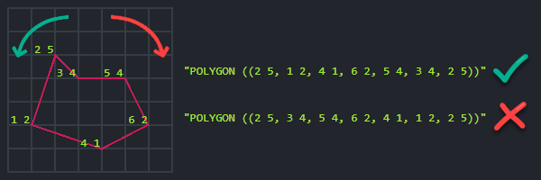
When using spatial.wkt() to define a polygon, the vertices (points that form the corners of the polygon) must be listed
in a counter-clockwise order:
Example I
- Sync
- Async
- RQL
// return all matching entities
// within 10 kilometers radius
// from 32.1234 latitude and 23.4321 longitude coordinates
List<House> results = session
  .Query<House>()
  .Spatial(
      factory => factory.Point(x => x.Latitude, x => x.Longitude),
      criteria => criteria.WithinRadius(10, 32.1234, 23.4321))
  .ToList();
// return all matching entities
// within 10 kilometers radius
// from 32.1234 latitude and 23.4321 longitude coordinates
List<House> results = await asyncSession
  .Query<House>()
  .Spatial(
      factory => factory.Point(x => x.Latitude, x => x.Longitude),
      criteria => criteria.WithinRadius(10, 32.1234, 23.4321))
  .ToListAsync();
from Houses
where spatial.within(spatial.point(Latitude, Longitude), spatial.circle(10, 32.1234, 23.4321))
Example II
- Sync
- Async
- RQL
// return all matching entities
// within 10 miles radius
// from 32.1234 latitude and 23.4321 longitude coordinates
// this equals to WithinRadius(10, 32.1234, 23.4321)
List<House> results = session
  .Query<House>()
  .Spatial(
      factory => factory.Point(x => x.Latitude, x => x.Longitude),
      criteria => criteria.RelatesToShape(
          "Circle(32.1234 23.4321 d=10.0000)",
          SpatialRelation.Within,
          SpatialUnits.Miles))
  .ToList();
// return all matching entities
// within 10 miles radius
// from 32.1234 latitude and 23.4321 longitude coordinates
// this equals to WithinRadius(10, 32.1234, 23.4321)
List<House> results = await asyncSession
  .Query<House>()
  .Spatial(
      factory => factory.Point(x => x.Latitude, x => x.Longitude),
      criteria => criteria.RelatesToShape(
          "Circle(32.1234 23.4321 d=10.0000)",
          SpatialRelation.Within,
          SpatialUnits.Miles))
  .ToListAsync();
from Houses
where spatial.within(spatial.point(Latitude, Longitude), spatial.wkt('Circle(32.1234 23.4321 d=10.0000)', 'Miles'))
OrderByDistance
To sort by distance from given point use the OrderByDistance method. The closest results will come first.
// From point
IOrderedQueryable<T> OrderByDistance<T>(
  Func<DynamicSpatialFieldFactory<T>, DynamicSpatialField> field,
  double latitude,
  double longitude);

IOrderedQueryable<T> OrderByDistance<T>(
  DynamicSpatialField field,
  double latitude,
  double longitude);

IOrderedQueryable<T> OrderByDistance<T>(
  Expression<Func<T, object>> path,
  double latitude,
  double longitude);

IOrderedQueryable<T> OrderByDistance<T>(
  string fieldName,
  double latitude,
  double longitude);

// From center of WKT shape
IOrderedQueryable<T> OrderByDistance<T>(
  Func<DynamicSpatialFieldFactory<T>, DynamicSpatialField> field,
  string shapeWkt);

IOrderedQueryable<T> OrderByDistance<T>(
  DynamicSpatialField field,
  string shapeWkt);

IOrderedQueryable<T> OrderByDistance<T>(
  Expression<Func<T, object>> path,
  string shapeWkt);

IOrderedQueryable<T> OrderByDistance<T>(
  string fieldName,
  string shapeWkt);

// Rounding
IOrderedQueryable<T> OrderByDistance<T>(
  Expression<Func<T, object>> path,
  double latitude,
  double longitude,
  double roundFactor);

IOrderedQueryable<T> OrderByDistance<T>(
  string fieldName,
  double latitude,
  double longitude,
  double roundFactor);

IOrderedQueryable<T> OrderByDistance<T>(
  Expression<Func<T, object>> path,
  string shapeWkt,
  double roundFactor);

IOrderedQueryable<T> OrderByDistance<T>(
  string fieldName,
  string shapeWkt,
  double roundFactor);
| Parameter | Type | Description |
|---|---|---|
| path | Expression<Func<T, object>> | Path to spatial field in index |
| fieldName | string | Path to spatial field in index |
| field | Func<DynamicSpatialFieldFactory<T>, DynamicSpatialField> or DynamicSpatialField | Factory or field that points to a dynamic field (used with auto-indexes). Either PointField or WktField |
| shapeWkt | string | WKT-based shape to be used as a point from which distance will be measured. If the shape is not a single point, then the center of the shape will be used as a reference. |
| latitude or longitude | double | Used to define a point from which distance will be measured |
| roundFactor | double | A distance interval in kilometers. The distance from the point is rounded up to the nearest interval. The results within the same interval are then sorted by another order. This other order is the next chained ordering, or if no other order was specified, then by ascending order of document Id. See example below. |
Example I
- Sync
- Async
- RQL
// return all matching entities
// within 10 kilometers radius
// from 32.1234 latitude and 23.4321 longitude coordinates
// sort results by distance from 32.1234 latitude and 23.4321 longitude point
List<House> results = session
  .Query<House>()
  .Spatial(
      factory => factory.Point(x => x.Latitude, x => x.Longitude),
      criteria => criteria.WithinRadius(10, 32.1234, 23.4321))
  .OrderByDistance(
      factory => factory.Point(x => x.Latitude, x => x.Longitude), 32.1234, 23.4321)
  .ToList();
// return all matching entities
// within 10 kilometers radius
// from 32.1234 latitude and 23.4321 longitude coordinates
// sort results by distance from 32.1234 latitude and 23.4321 longitude point
List<House> results = await asyncSession
  .Query<House>()
  .OrderByDistance(
      factory => factory.Point(x => x.Latitude, x => x.Longitude), 32.1234, 23.4321)
  .ToListAsync();
from Houses
where spatial.within(spatial.point(Latitude, Longitude), spatial.circle(10, 32.1234, 23.4321))
order by spatial.distance(spatial.point(Latitude, Longitude), spatial.point(32.1234, 23.4321))
Example II
This example demonstrates rounding. The query sorts the results by distance from
the specified point, but rounds the distance up to the nearest 100 km interval.
All results within the same interval are sorted alphabetically by the field Name.
- Sync
- Async
- RQL
// Return all entities and sort results by distance.
// Round the distance up to the nearest 100 km.
// Then sort alphabetically by the entity Name.
List<House> results = session
  .Query<House>()
  .OrderByDistance(
      factory => factory.Point(
          x => x.Latitude,
          x => x.Longitude)
      .RoundTo(100),
      32.1234,
      23.4321)
  .ThenBy(x => x.Name)
  .ToList();
// Return all entities and sort results by distance.
// Round the distance up to the nearest 100 km.
// Then sort alphabetically by the entity Name.
List<House> results = await asyncSession
  .Query<House>()
  .OrderByDistance(
      factory => factory.Point(
          x => x.Latitude,
          x => x.Longitude)
      .RoundTo(100),
      32.1234,
      23.4321)
  .ThenBy(x => x.Name)
  .ToListAsync();
from Houses as h
order by spatial.distance(
  spatial.point(h.Latitude, h.Longitude),
  spatial.point(32.1234, 23.4321),
  100), h.Name
OrderByDistanceDescending
To sort by distance from given point use the OrderByDistanceDescending method. The farthest results will come first.
// From point
IOrderedQueryable<T> OrderByDistanceDescending<T>(
  Func<DynamicSpatialFieldFactory<T>, DynamicSpatialField> field,
  double latitude,
  double longitude);

IOrderedQueryable<T> OrderByDistanceDescending<T>(
  DynamicSpatialField field,
  double latitude,
  double longitude);

IOrderedQueryable<T> OrderByDistanceDescending<T>(
  Expression<Func<T, object>> path,
  double latitude,
  double longitude);

IOrderedQueryable<T> OrderByDistanceDescending<T>(
  string fieldName,
  double latitude,
  double longitude);

// From center of WKT shape
IOrderedQueryable<T> OrderByDistanceDescending<T>(
  Func<DynamicSpatialFieldFactory<T>, DynamicSpatialField> field,
  string shapeWkt);

IOrderedQueryable<T> OrderByDistanceDescending<T>(
  DynamicSpatialField field,
  string shapeWkt);

IOrderedQueryable<T> OrderByDistanceDescending<T>(
  Expression<Func<T, object>> path,
  string shapeWkt);

IOrderedQueryable<T> OrderByDistanceDescending<T>(
  string fieldName,
  string shapeWkt);

// Rounding
IOrderedQueryable<T> OrderByDistanceDescending<T>(
  Expression<Func<T, object>> path,
  double latitude,
  double longitude,
  double roundFactor);

IOrderedQueryable<T> OrderByDistanceDescending<T>(
  string fieldName,
  double latitude,
  double longitude,
  double roundFactor);

IOrderedQueryable<T> OrderByDistanceDescending<T>(
  Expression<Func<T, object>> path,
  string shapeWkt,
  double roundFactor);

IOrderedQueryable<T> OrderByDistanceDescending<T>(
  string fieldName,
  string shapeWkt,
  double roundFactor);
| Parameter | Type | Description |
|---|---|---|
| path | Expression<Func<T, object>> | Path to spatial field in an index |
| fieldName | string | Path to spatial field in an index |
| field | Func<DynamicSpatialFieldFactory<T>, DynamicSpatialField> or DynamicSpatialField | Factory or field that points to a dynamic field (used with auto-indexes). Either PointField or WktField |
| shapeWkt | string | WKT-based shape to be used as a point from which distance will be measured. If the shape is not a single point, then the center of the shape will be used as a reference. |
| latitude or longitude | double | Used to define a point from which distance will be measured |
| roundFactor | double | A distance interval in kilometers. The measured distance is rounded up to the nearest interval. The results within the same distance interval are then sorted by another order. This other order is the next chained ordering, or if no other order was specified, then by ascending order of document Id. See example above. |
Example
- Sync
- Async
- RQL
// return all matching entities
// within 10 kilometers radius
// from 32.1234 latitude and 23.4321 longitude coordinates
// sort results by distance from 32.1234 latitude and 23.4321 longitude point
List<House> results = session
  .Query<House>()
  .Spatial(
      factory => factory.Point(x => x.Latitude, x => x.Longitude),
      criteria => criteria.WithinRadius(10, 32.1234, 23.4321))
  .OrderByDistanceDescending(
      factory => factory.Point(x => x.Latitude, x => x.Longitude), 32.1234, 23.4321)
  .ToList();
// return all matching entities
// within 10 kilometers radius
// from 32.1234 latitude and 23.4321 longitude coordinates
// sort results by distance from 32.1234 latitude and 23.4321 longitude point
List<House> results = await asyncSession
  .Query<House>()
  .Spatial(
      factory => factory.Point(x => x.Latitude, x => x.Longitude),
      criteria => criteria.WithinRadius(10, 32.1234, 23.4321))
  .OrderByDistanceDescending(
      factory => factory.Point(x => x.Latitude, x => x.Longitude), 32.1234, 23.4321)
  .ToListAsync();
from Houses
where spatial.within(spatial.point(Latitude, Longitude), spatial.circle(10, 32.1234, 23.4321))
order by spatial.distance(spatial.point(Latitude, Longitude), spatial.point(32.1234, 23.4321)) desc
Remarks
By default, distances are measured in kilometers.